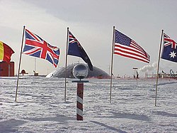
The Geographic South Pole is located on the continent of Antarctica (although this has not been the case for all of Earth's history because of continental drift). It sits atop a featureless, windswept, icy plateau at an altitude of 2,835 metres (9,306 ft), about 1,300 km (800 mi) from the nearest open sea at Bay of Whales. The ice is estimated to be about 2,700 metres (9,000 ft) thick at the Pole, so the land surface under the ice sheet is actually near sea level.[2]
The polar ice sheet is moving at a rate of roughly 10 metres per year in a direction between 37° and 40° west of grid north,[3] down towards the Weddell Sea. Therefore, the position of the station and other artificial features relative to the geographic pole gradually shifts over time.
The Geographic South Pole is marked by a small sign and a stake in the ice pack, which are repositioned each year on New Year's Day to compensate for the movement of the ice.[4] The sign records the respective dates that Roald Amundsen and Robert F. Scott reached the Pole, followed by a short quotation from each man and gives the elevation as 2,835 m (9,301 ft).[5]
No comments:
Post a Comment